Welcome to Cuyahoga Valley National Park.
Looking for the top 16 Cuyahoga Valley hikes?
Discover them below!
If you already want to have a taste of Cuyahoga Valley National Park, watch the video below!
KEY TAKEAWAYS:
- 📜 History: Cuyahoga Valley’s name and landscape reflect its history as a Native American trade route and later a canal-driven industrial hub.
- 🥾 Epic Cuyahoga Valley hikes: With over 125 miles of trails, including waterfall loops, cliffside paths, and forest walks, there’s a scenic route for every level.
- 🦌 Wildlife wonderland: Spot deer, owls, beavers, and 250+ bird species across the park’s wetlands, meadows, and riverside habitats.
Overview of Cuyahoga Valley National Park hikes
Take a look below at the summary of 16 hikes in the Cuyahoga Valley National Park.
Afterward, we’ll delve into each one specifically!
| Trail name | Distance (miles) | Hiking time | Highlights / Special features |
| Brandywine Gorge Trail | 1.5 | 1–1.5 hours | 60-foot Brandywine Falls, sandstone gorge |
| Ledges Trail | 2.2 | 1.5–2 hours | Ritchie Ledges, panoramic overlook, Ice Box Cave |
| Buckeye Trail | 2.5 | 1.5–2 hours | Blue Hen Falls, hardwood forest |
| Pine Grove Trail | 2.2 | 1–1.5 hours | Towering pines, fall foliage, birdwatching |
| Blue Hen Falls via Buckeye | 3.0 | 1.5–2 hours | 15-foot waterfall, wooded ravines |
| Deer Lick Cave Loop | 4.2 | 1.5–2 hours | Sandstone cave, waterfall, wooden bridges |
| Valley Bridle Trail | 2.75 | 1.5–2 hours | Everett Covered Bridge, Cuyahoga River |
| Bridal Veil Falls to Tinker’s Gorge | 2.0 | 1–1.5 hours | Veil waterfall, Tinker’s Creek Gorge |
| Kendall Lake & Salt Run | 4.75 | 2–2.5 hours | Kendall Lake, wooded hills, wildlife |
| Furnace Run MetroPark | 2.8 | 1–1.5 hours | Old Mill, Rock Creek, daffodil bloom |
| Towpath Trail | 0.5–10.0 | 30 min to 4+ hours | Ohio & Erie Canal, historic lock sites |
| Deer Run Trail | 2.0 | 1–1.5 hours | Yellow Creek, historic barn |
| Plateau Trail | 4.9 | 2–2.5 hours | Meadows, ponds, Oak Hill woods |
| Boston Run Trail | 3.1 | 1.5–2 hours | Ravines, beech-maple forest, Boston Run stream |
| Tree Farm Trail | 2.8 | 1–1.5 hours | Horseshoe Pond, pine groves, wildlife |
| Deep Lock Quarry | 1.3 | 30 minutes | Lock 28, sandstone quarry, Cuyahoga River |
History of Cuyahoga Valley National Park
Cuyahoga Valley National Park was officially named in 2000, but its history goes back much further.
The Cuyahoga River, which means “crooked river” in Mohawk, was a famous trade route for Native American tribes.
During the 19th century, the construction of the Ohio & Erie Canal made the region into a hub for trade and migration.
Today, the park preserves over 33,000 acres between the cities of Cleveland and Akron, with more than 2 million visitors annually, according to the Conservancy of the park.
Wildlife in Cuyahoga Valley
The Cuyahoga Valley is renowned for its diverse landscapes, ranging from wooded ravines and sandstone ledges to wetlands, rivers, and meadows.
The park has over 125 MILES (!) of hiking trails, including popular routes like the Ledges Trail, Brandywine Gorge Trail, and the 87-mile Towpath Trail that follows the historic canal. Those trails belong to the best trails for hiking in Cleveland!
There is quite a lot of wildlife in the national park, including:
- White-tailed deer, foxes, and raccoons
- Great blue herons and barred owls in wetlands
- Beavers and turtles along the Cuyahoga River
- More than 250 bird species

Popular Cuhayoga Valley hikes
Now, let’s look at all the Cuhayoga Valley hikes individually.
1. Brandywine Gorge Trail to Brandywine Falls in Cuyahoga Valley National Park
- Distance: 1.5 miles (2.4 kilometers) loop
- Hiking time: 1–1.5 hours
- Elevation gain: 160 feet (49 meters)
- Time to reach by car: 30 minutes from downtown Cleveland
- Permit required: No
- Location: NORTHFIELD, OHIO
One of the most famous Cuyahoga Valley hikes is the Brandywine Gorge Trail.
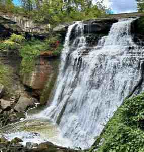
It starts at the Brandywine Falls Parking Lot on Brandywine Road. It begins with a boardwalk leading to an overlook of the 60-foot Brandywine Falls, the TALLEST WATERFALL in Cuyahoga Valley National Park.
The falls cascade over layers of Berea Sandstone and Bedford Shale, creating a stunning geological view for Instagram-worthy pictures.
Continuing on the loop, the trail descends into the gorge, following a dirt path alongside Brandywine Creek.
The trail then ascends back to the parking area, completing the loop.
👉 INSIDER TIP: For a longer adventure, consider starting from the Stanford Trailhead, which connects to the Brandywine Gorge Loop for a 3.8-mile (6.1-kilometer) round trip with a cumulative 400-foot (122-meter) elevation change.
“Nice, easy trail to walk in the afternoon. We also went down the boardwalk to see the falls closer since it was just a quick detour off this loop.“
You can find more information on the official park map.
2. Ledges Trail
- Distance: 2.2 miles (3.5 kilometers) loop
- Hiking time: 1.5–2 hours
- Elevation gain: 105 feet (32 meters)
- Time to reach by car: 30 minutes from downtown Cleveland
- Permit required: No
- Location: PENINSULA, OHIO
The Ledges Trail is a must-do for anyone exploring Cuyahoga Valley National Park. It’s one of the best hiking experiences in Cleveland!
This loop trail winds through rock formations known as the Ritchie Ledges, offering you an insight into the park’s geological history.
Starting at the Ledges Trailhead on Kendall Park Road, the path leads you through dense forests and along massive sandstone cliffs.
The trail’s highlight is the Ledges Overlook, providing panoramic views of the Cuyahoga Valley.
Along the way, you’ll encounter moss-covered rocks, narrow passages, and the intriguing ICE BOX CAVE*.
*Please note that the cave is currently closed to protect local bat populations from white-nose syndrome.
👉 INSIDER TIP: For a quieter experience, consider hiking early in the morning or on weekdays, as the trail can become crowded during peak times.
“The entire trail was the destination. Great views! It was easy to get sidetracked on other trails, so I had to look at the map.
You can find more information on the official park map.
3. Buckeye Trail
- Distance: 2.5 miles (4 kilometers) round trip
- Hiking time: 1.5–2 hours
- Elevation gain: 312 feet (95 meters)
- Time to reach by car: 30 minutes from downtown Cleveland
- Permit required: No
- Location: PENINSULA, OHIO
The Buckeye Trail begins at the Boston Mill Visitor Center, a central hub in Cuyahoga Valley National Park.
As you progress, the trail descends into a ravine, leading to the picturesque Blue Hen Falls (see more later).
This 15-foot waterfall cascades over a sandstone ledge.
The trail’s moderate difficulty includes some steep inclines and uneven terrain, so we recommend sturdy footwear.
👉 INSIDER TIP: For a more extended adventure, continue past Blue Hen Falls to explore BUTTERMILK FALLS, a lesser-known waterfall that offers a more secluded experience.
ALLTRAILS REVIEW:
“This state nature preserve requires a permit for access. I’ve been here several times, and I’m still amazed at the cliffs that stand well over 100 feet in several places.“
You can find more information on the official park map.
Discover more United States guides on our blog!
4. Pine Grove Trail
- Distance: 2.2 miles (3.5 kilometers) loop
- Hiking time: 1–1.5 hours
- Elevation gain: 105 feet (32 meters)
- Time to reach by car: 35 minutes from downtown Cleveland
- Permit required: No
- Location: PENINSULA, OHIO
Starting at the Octagon Shelter Trailhead on Kendall Park Road, the Pine Grove Trail meanders through a forest filled with giant pine and hemlock trees.
The well-maintained dirt path is relatively flat, making it accessible for hikers of all skill levels.
This trail is excellent during the fall, when the leaves of the trees transform into a tapestry of colors, offering stunning views that strengthen the park’s natural beauty.
👉 INSIDER TIP: Combine the Pine Grove Trail with the Ledges Trail for an extended hike that showcases the park’s dramatic sandstone formations and the iconic Ledges Overlook.

“The rocks caught my eye in other reviews of this trail, but for this specific trail, there are no rock formations! Beautiful hike with the plethora of trees but just wanted to note this specific trail didn’t include the rocks, I’m sure if you venture off you’ll find them! Also, a couple of trees block the path about halfway through the loop, but easy to navigate through.“
You can find more information on the official park map.
5. Blue Hen Falls via Buckeye Trail
- Distance: 3.0 miles (4.8 kilometers) round trip
- Hiking time: 1.5–2 hours
- Elevation gain: 580 feet (177 meters)
- Time to reach by car: 30 minutes from downtown Cleveland
- Permit required: No
- Location: PENINSULA, OHIO
Starting at the Boston Mill Visitor Center, the Blue Hen Falls follows the Buckeye Trail, marked by blue blazes. It’s one of the BEST Cuyahoga Valley hikes!
The trail features a mix of terrains, including steep inclines, wooden steps, and creek crossings.
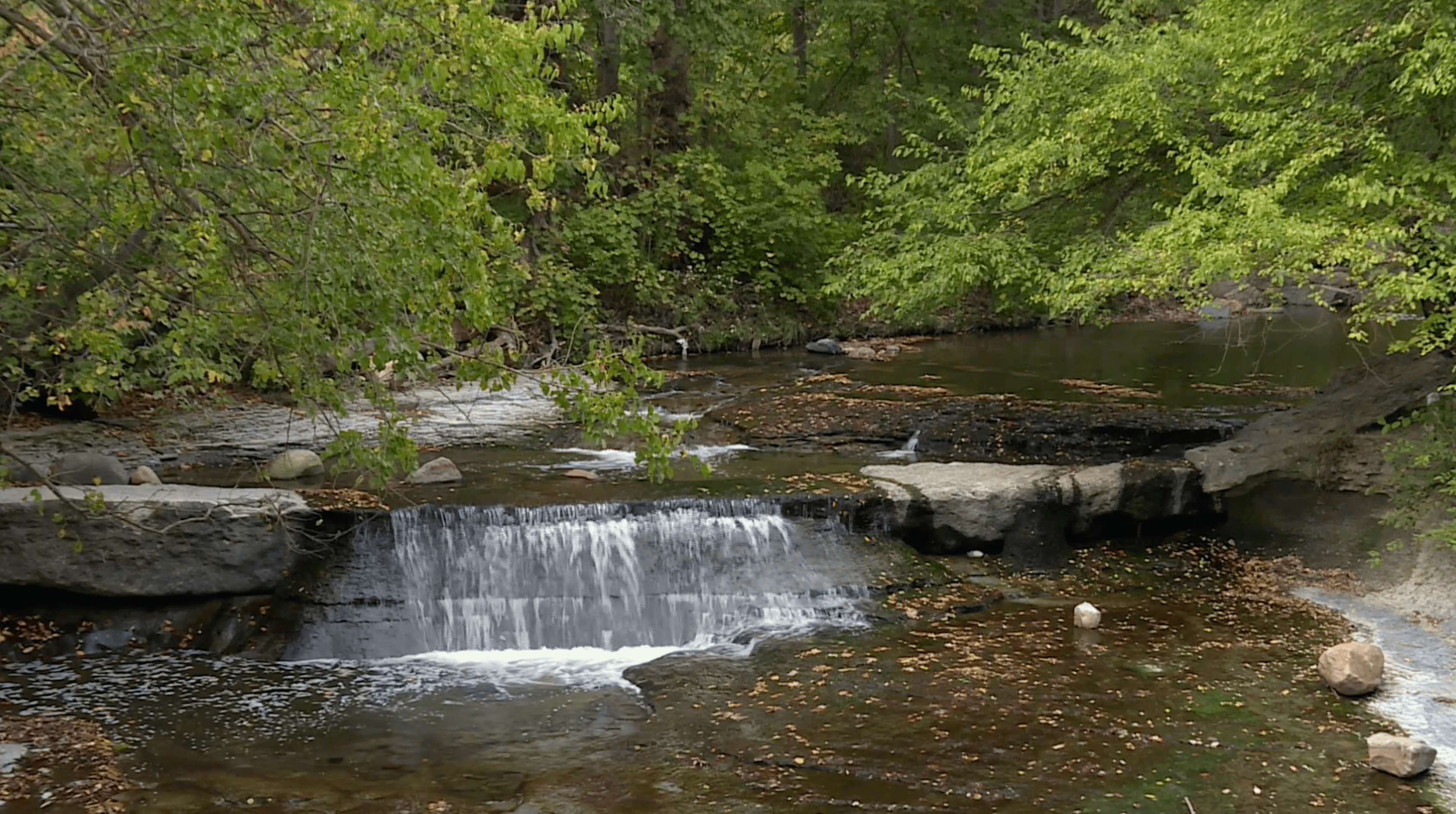
The highlight is the 15-foot Blue Hen Falls, cascading over a sandstone ledge into a pool below.
The falls are especially captivating after rainfall, offering stunning views amidst the lush greenery.
You can find more information on the official park map.
6. Deer Lick Cave Loop Trail
- Distance: 4.2 miles (6.8 kilometers) loop
- Hiking time: 1.5–2 hours
- Elevation gain: 498 feet (152 meters)
- Time to reach by car: 30 minutes from downtown Cleveland
- Permit required: No
- Location: BRECKSVILLE, OHIO
Starting at the Brecksville Nature Center on Chippewa Creek Drive, the trail meanders through the Brecksville Reservation, a part of the Cuyahoga Valley National Park.
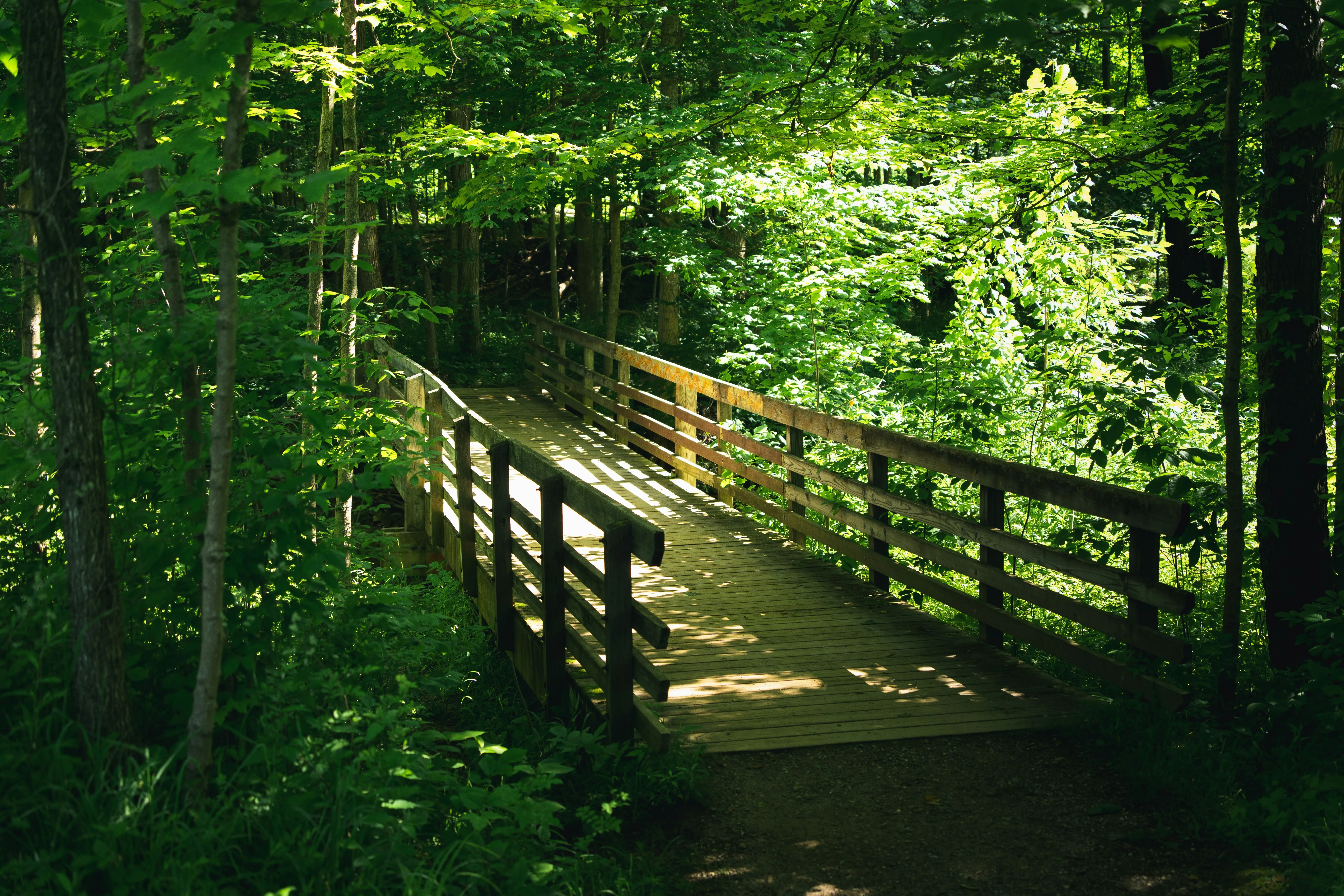
The path is well-marked with oak leaf blazes, guiding you through a landscape with native plants, wooden bridges, and the sounds of creeks.
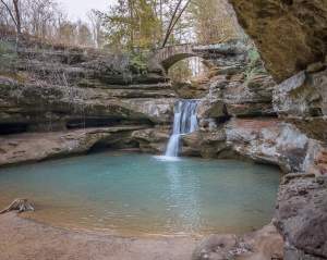
The trail’s namesake, Deer Lick Cave, is a sandstone overhang formed through years of erosion.
White-tailed deer were often seen licking the mineral-rich walls, hence the name.
👉 INSIDER TIP: For a shorter hike, start at the Deer Lick Cave Trailhead on Valley Parkway. A brief 0.5-mile (0.8-kilometer) loop leads directly to the cave and waterfall, making it accessible for families with kids.
TRIPADVISOR REVIEW:
“There were some horses on the trail! There are beautiful stream crossings and a great trail. Didn’t feel too difficult and went by fast 🙂“
7. Valley Bridle Trail (with a stop at Everett Covered Bridge)
- Distance: 2.75 miles (4.4 kilometers) one-way
- Hiking time: 1.5–2 hours
- Elevation gain: Varied
- Time to reach by car: Approximately 35 minutes from downtown Cleveland
- Permit required: No
- Location: PENINSULA, OHIO
Starting at the Everett Covered Bridge Trailhead (2370 Everett Road), this section of the Valley Bridle Trail meanders through woodlands, open fields, and along the curves of the Cuyahoga River.
The trail is shared with horseback riders.

The highlight of this hike is the Everett Covered Bridge, the only remaining covered bridge in Summit County, Ohio.
Initially built in the 1800s, it was destroyed by a flood in 1975 and reconstructed in 1986.
👉 INSIDER TIP: For an addition to your Cuyahoga Valley hikes, plan a stop at Szalay’s Farm & Market, located near the trail.
Discover more United States guides on our blog!
8. Bridal Veil Falls to Tinker’s Creek Gorge
- Distance: 2.0 miles (3.2 kilometers) round trip
- Hiking time: 1–1.5 hours
- Elevation gain: 83 feet (25 meters)
- Time to reach by car: 30 minutes from downtown Cleveland
- Permit required: No
- Location: WALTON HILLS, OHIO
Starting at the Bridal Veil Falls Trailhead on Gorge Parkway, this hike begins with a short descent via a boardwalk and steps to the Bridal Veil Falls.
This 20-foot waterfall cascades over layered shale.
After enjoying the falls, retrace your steps to the trailhead and continue northwest on the Buckeye Trail. The path meanders through a dense forest of hardwoods and hemlocks.
One mile in, you’ll arrive at the Tinker’s Creek Gorge Overlook, a designated National Natural Landmark. From this vantage point, gaze upon the 896-foot-deep gorge carved by Tinker’s Creek, the largest tributary of the Cuyahoga River.
You can find more information on the official park map.

9. Kendall Lake Loop and Salt Run Trail
- Distance: Kendall Lake Loop: 1.5 miles (2.4 kilometers); Salt Run Trail: 3.25 miles (5.2 kilometers)
- Hiking time: Kendall Lake Loop: 30–45 minutes; Salt Run Trail: 1.5–2 hours
- Elevation gain: Kendall Lake Loop: 91 feet (28 meters); Salt Run Trail: 160 feet (49 meters)
- Time to reach by car: 35 minutes from downtown Cleveland
- Permit required: No
- Location: PENINSULA, OHIO
Begin your journey at the Kendall Lake Trailhead, where a well-maintained path encircles the tranquil Kendall Lake.
This loop is predominantly flat, with a dirt surface and a few sets of stairs, making it accessible for hikers of all levels.
The trail offers picturesque views of the lake, opportunities to observe native plants and wetlands, and chances to spot wildlife, including beavers and various bird species.
From the lake loop, transition onto the Salt Run Trail, a more challenging path that meanders through wooded ravines and rolling hills.
This trail is renowned for its significant elevation changes and root-laden terrain, offering a moderate to challenging hike.
Along the way, Cuyahoga Valley hikers can enjoy the lush greenery, spot wildlife, and experience the natural beauty that defines Cuyahoga Valley National Park.
You can find more information on the official park map.

10. Furnace Run MetroPark
- Distance: 2.8 miles (4.5 kilometers) when combining the Old Mill and Rock Creek Trails
- Hiking time: 1–1.5 hours
- Elevation gain: 133 feet (40 meters)
- Time to reach by car: 35 minutes from downtown Cleveland
- Permit required: No
- Location: RICHFIELD, OHIO
Begin your hike at the Brushwood Area, located at 4955 Townsend Road. The Old Mill Trail is a 1.4-mile (2.3-kilometer) loop that takes you through beech-maple forests and past historical markers, including a tribute to the Brush family, early contributors to the park’s development.
It’s one of the BEST Cuyahoga Valley hikes!
Connecting to the Old Mill Trail is the Rock Creek Trail, a 1.3-mile (2.1-kilometer) loop that follows the scenic Rock Creek.
For a shorter hike, the Daffodil Trail is a 0.8-mile (1.3-kilometer) loop renowned for its vibrant spring blooms.
Each March and April, thousands of daffodils planted by the park’s first director, H.S. Wagner, create a stunning display along this trail.
You can find more information on the official park map.
Discover more United States guides on our blog!
11. Towpath Trail
- Distance: 87 miles (140 kilometers) total; various segments in CVNP from 0.5 to 10 miles (0.8 to 16 kilometers)
- Hiking time: Varies by segment (30 minutes to 4+ hours)
- Elevation gain: Minimal (mostly flat)
- Time to reach by car: 25–40 minutes from downtown Cleveland (multiple trailheads)
- Permit required: No
- Location: CUYAHOGA VALLEY NATIONAL PARK, OHIO
12. Deer Run Trail
- Distance: 2.0 miles (3.2 kilometers) loop
- Hiking time: 1–1.5 hours
- Elevation gain: 275 feet (84 meters)
- Time to reach by car: Approximately 35 minutes from downtown Cleveland
- Permit required: No
- Location: AKRON, OHIO
13. Plateau Trail
- Distance: 4.9 miles (7.9 kilometers) loop
- Hiking time: 2–2.5 hours
- Elevation gain: 200 feet (61 meters)
- Time to reach by car: Approximately 35 minutes from downtown Cleveland
- Permit required: No
- Location: PENINSULA, OHIO
The Plateau Trail is a moderately challenging loop that meanders through diverse habitats, including dense forests, open meadows, and serene ponds.
Starting at the Oak Hill Trailhead on Oak Hill Road, this trail provides hikers with a peaceful retreat, offering opportunities to observe native plants and wildlife.
14. Boston Run Trail
- Distance: 3.1 miles (5.0 kilometers) loop
- Hiking time: 1.5–2 hours
- Elevation gain: 80 feet (24 meters)
- Time to reach by car: Approximately 35 minutes from downtown Cleveland
- Permit required: No
- Location: PENINSULA, OHIO
The Boston Run Trail offers a moderately challenging loop through the heart of Cuyahoga Valley National Park.
Starting at the Happy Days Lodge parking lot, the trail meanders through dense forests of beech, oak, and maple trees alongside ravines and the Boston Run stream.
15. Tree Farm Trail
- Distance: 2.8 miles (4.5 kilometers) loop
- Hiking time: 1–1.5 hours
- Elevation gain: 80 feet (24 meters)
- Time to reach by car: 35 minutes from downtown Cleveland
- Permit required: No
- Location: PENINSULA, OHIO
16. Deep Lock Quarry
- Distance: 1.3 miles (2.1 kilometers) out-and-back
- Hiking time: 30 minutes
- Elevation gain: 114 feet (35 meters)
- Time to reach by car: 35 minutes from downtown Cleveland
- Permit required: No
- Location: PENINSULA, OHIO
Seasonal hiking experiences
- Spring blooms and flora: Trails like the Salt Run Trail and Pine Grove Trail come alive with wildflowers and native plant blossoms.
- Summer greenery and activities: Explore shaded paths like the Brandywine Gorge Trail or the Towpath Trail, and pair hikes with kayaking or biking in the lush, full-canopy warmth of summer.
- Autumn fall foliage: Iconic Cuyahoga Valley hikes like the Ledges Trail, Tree Farm Trail, and Boston Run Trail offer stunning displays of red, gold, and amber—this is the park’s busiest time for a reason.
- Winter wonderland scenery: Snow-dusted trails, such as the Kendall Lake Loop and Deer Run Trail, offer peaceful solitude, icy streams, and scenic beauty, with a chance to spot animal tracks and enjoy a quiet escape.
FAQ
What is the most popular hike at Cuyahoga Valley National Park?
The Brandywine Gorge Trail is widely considered the most popular hike at Cuyahoga Valley National Park. This 1.5-mile loop takes you through shaded forests and along the gorge carved by Brandywine Creek, leading to the park’s most iconic feature, Brandywine Falls, a stunning 60-foot cascading waterfall. With its scenic boardwalks, easy access from Brandywine Road, and rewarding views, it’s a favorite among both first-time visitors and local hikers. To avoid crowds, plan your visit on weekday mornings or during the shoulder seasons of spring and fall.
What not to miss in Cuyahoga Valley National Park?
If you're exploring Cuyahoga Valley National Park for the first time, don’t miss these top highlights:
- Brandywine Falls via the Brandywine Gorge Trail
- The towering sandstone cliffs of the Ledges Trail
- A relaxing walk or bike ride along the Ohio & Erie Canal Towpath Trail
- Scenic views from Tinker’s Creek Gorge Overlook
- The historic Everett Covered Bridge on the Valley Bridle Trail
These spots represent the diversity of Cuyahoga Valley hikes—from waterfalls and rock formations to canal history and peaceful forests.
What is the best waterfall trail in Cuyahoga Valley National Park?
The best waterfall trail in Cuyahoga Valley National Park is hands-down the Brandywine Gorge Trail. This short but rewarding loop offers up-close views of Brandywine Falls, the tallest waterfall in the park. If you're looking for a quieter alternative, the Buckeye Trail to Blue Hen Falls is a close second—offering a peaceful 3-mile out-and-back hike to a beautiful 15-foot waterfall surrounded by woodland serenity.
What is the hardest trail in Cuyahoga Valley National Park?
The Salt Run Trail is often considered one of the hardest hikes in Cuyahoga Valley National Park, especially when combined with the Cross Country Trail. This 3.25-mile loop features steep inclines, root-covered paths, and rugged terrain that challenge even experienced hikers. Other contenders include the Boston Run Trail for its uneven terrain and the Buckeye Trail extensions near Buttermilk Falls for their elevation gain and stream crossings. If you're seeking a true workout, these Cuyahoga Valley hikes deliver both adventure and reward.