

Welcome to the famous Mount Otemanu in Bora Bora, French Polynesia.
In this blog post, we’ll cover EVERYTHING you need to know about this extinct volcano, from how to hike it to the history and other activities!
This guide is perfect for a FIRST TIMER’S VISIT to Mt. Otemanu!
Do you want to get a good idea of what it feels like to hike and sometimes climb with ropes to summit Otemanu? Check out the video below!
KEY TAKEAWAYS:
- 🌋 Height: Mount Otemanu is the TALLEST mountain in Bora Bora, 727 meters (2,385 feet) above sea level.
- 🚁 Activities: Mount Otemanu is used for three activities: hiking, 4×4 tours, and helicopter rides.
- 🌺 Culture: The mountain holds cultural and spiritual meaning for the people of Bora Bora, with local legends and its role during World War II.
Why is Mount Otemanu so famous?
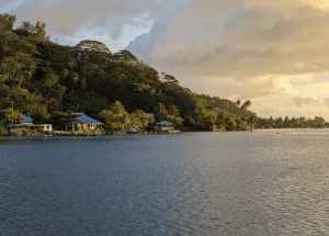
Mount Otemanu is the highest point on Bora Bora
Mount Otemanu is famous for being not only the highest mountain in Bora Bora but also a DORMANT VOLCANO!
The Bora Bora mountain is the HIGHEST POINT of the island at 727 meters (2,385 feet) from the surface of a turquoise lagoon.
This mountain alone is just as famous on Instagram as most Society islands, such as Maupiti and Huahine.
Discover Mount Otemanu and other activities on our detailed map of Bora Bora below!
TRIPADVISOR REVIEW: This mountain is what makes Bora Bora so special, without it would be just another pretty island. Mount Otemanu makes Bora Bora magical and the view of it is breathtaking.
Locals even call Mount Otemanu “HEAVEN ON EARTH,” as seen from every part of the island.
INTERESTING FACT: In the Tahitian language, the name “Otemanu” translates to “mountain that swallows people.”
Mount Otemanu played a role in World War II
DID YOU KNOW that Mount Otemanu played a crucial role during World War II?
The island was chosen to be a REFUELING BASE for the United States, and Mt. Otemanu provided a high vantage point from which to place large CANNONES and RADAR EQUIPMENT for maximum effectiveness.

TOP activities at Mount Otemanu
Next to climbing, which we cover below, you can do two other activities at Mt. Otemanu.
1) Helicopter Tour
Experience the Mount Otemanu from the sky with a breathtaking helicopter tour.
This experience offers a bird’s-eye view of the rugged nature of the mountain.
But it doesn’t stop there. You can also see the turquoise lagoon and some of the most luxurious resorts in the world, like the St. Regis Resort and the Four Seasons Resort, from the sky.
Price: Starting at USD 360 / EURO 323 per person
Website: Helicopter Tours Bora Bora
2) 4×4 Safari Tour
Explore the jungle terrain around Mount Otemanu on a 4×4 safari tour.
This off-road adventure takes you into Bora Bora’s nature, showing valleys, historic World War II sites, ancient Polynesian temples, and viewpoints of the lagoon.
You’ll get to see Bora Bora’s fauna and flora up close, with its rich volcanic soil, home to hibiscus flowers, pandanus trees, and coconut palms.
Price: USD 299 (€275) per person (includes lunch and a combined jet ski tour)
Website: Bora Bora Adventure Tour
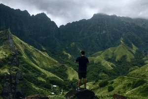
Can you climb Mount Otemanu in Bora Bora?
YES!
You can climb Mount Otemanu in Bora Bora.
However, it is IMPOSSIBLE TO GET TO THE HIGHEST POINT because of loose rocks.
Here’s a breakdown of the most important things you should know about the Mount Otemanu climb:
- Guided Tours are MANDATORY. The terrain is complex, and there is no path, requiring informed guides who know the paths and can ensure your safety.
- Physical: The hike is quite difficult, with some parts where you must do some climbing. But, if a 66-year-old person can make it (oldest recorded age), and a kit of 8 years old, then you can do it!
- Permits for Mount Otemanu: No special permit is required. However, booking through a registered tour operator is necessary for access and guidance.
TRIPADVISOR REVIEW: What started out as a medium intensity hike with amazing views eventually got pretty hard core, but capable for an average joe as long as you are dressed right and willing to put in some work. At many points it was so steep we had to use ropes to scale up. Once we got into the sacred cave and got to relax it was amazing to take to in the view.
Even Lonely Planet calls this hike the ‘best hike for bragging rights‘.
How long does it take to climb Mount Otemanu?
It takes about 2–2.5 hours to climb the mountain. A bit less to come back down.
Legend of the Ana o Pea cave on Mount Otemanu
A cave on Mount Otemanu, known as the Ana o Pea or the Cave of the Swallow, is culturally and historically important in Bora Bora.
According to LOCAL LEGEND, it represents the goddess of the AIR. However, when you are in the cave, you can hear the screams of a child at night.
Today, inside the cave, there are cavities where frigate birds nest, and certain areas were believed to have once been used as resting places for esteemed ancestors.
Is there a volcano in Bora Bora?
Yes, Mount Otemanu is an ancient volcano.
This extinct volcano is 727 meters (2,385 feet) above sea level. Together with Mount Pahia, it forms Bora Bora, an island built on volcanic activity that occurred seven million years ago.
Over millions of years, erosion shaped the island, leaving the mountain as a rugged centerpiece surrounded by a turquoise lagoon and barrier reef protecting the lagoon from the waves of the Pacific Ocean.
DID YOU KNOW: Mount Otemanu is composed of basalt, a volcanic rock that gives it its distinct dark coloration.
According to Wikipedia, the Bay of Tuuraapuo served as the crater of the ancient volcano.
It now separates the main island from two volcanic islets, Toopua and Toopua-iti, remnants of the southwestern edge that collapsed over time.

When was the last time Bora Bora erupted?
The volcanic eruptions that formed Bora Bora have stopped around 3,000 years ago.
Over millions of years, many eruptions shaped the island’s present form.
Is Bora Bora at risk of a tsunami?
Given its location in the Pacific Ocean’s “Ring of Fire,“ Bora Bora, like many islands in this area, is theoretically at risk of tsunamis.
This risk stems from the potential for UNDERWATER EARTHQUAKES AND VOLCANIC ERUPTIONS in the Pacific, which can generate massive waves.
However, it’s important to note that the island’s surrounding REEF BARRIER plays a big role in reducing the impact of possible tsunamis. It acts as a natural barrier that diminishes wave energy before it reaches the shore.
Bora was not considered particularly vulnerable to the tsunami. No tsunami occurred recently across the region, even though the island is far from the major earthquake zones of the Pacific.
What are the mountains in Bora Bora called?
There are two mountains in Bora Bora, Mount Otemanu and Mount Pahia.
- Mount Otemanu is taller, reaching 727 meters (2,385 feet) above sea level.
- Mount Pahia is 661 meters (2,169 ft) high. Its slopes are more accessible, making it a challenging hike that rewards you with panoramic views of the island and its surrounding ocean.
What is the tallest mountain in Bora Bora?
Mount Otemanu is Bora Bora’s tallest mountain, reaching 727 meters (2,385 feet) above sea level.
This peak dominates the island’s skyline, as can be seen everywhere.
Its steep, craggy sides comprise rugged basalt formations, remnants of the island’s volcanic origins.


2 Responses
Very interesting information. Thank you! I would be interested in knowing more about the WW2 connection, armory present during the period, action seen, etc if you have a reference.
Thank you.
Hi Bob, Sure!
When we visited the island, our guide explained to us that, after Japan attacked Pearl Harbor, the United States entered World War II and used Bora Bora as a strategic military base in the South Pacific. Called “Operation Bobcat (https://codenames.info/operation/bobcat/),” the U.S. built an oil depot, airstrip, seaplane base, and defence fortifications on the island. The base housed around 4,500 personnel, six ships, and 20,000 tons of equipment. To protect against possible attacks, seven large naval cannons were placed at key points around Bora Bora.
Hope this helped you!