
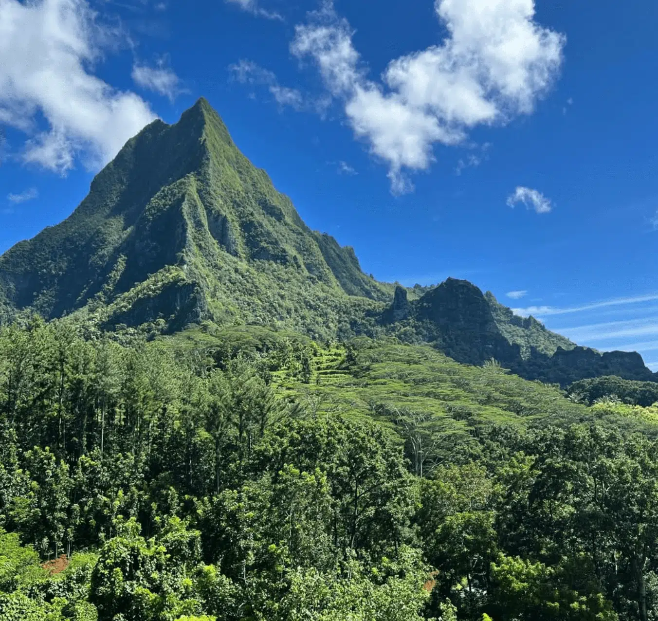
Welcome to Mount Rotui in Moorea, French Polynesia!
What is it like climbing the mountain, and what do you need to know before you go?
Take a look at the video below to see the climb!
KEY TAKEAWAYS:
- Mount Rotui, at 899 meters (2,949 feet), is the second-highest peak on Moorea, offering a challenging hike with steep climbs.
- Spanning 7 kilometers (4.3 miles) roundtrip, the hike takes 5–6 hours to complete.
- Unlike Moorea’s crowded lagoons and resorts, Mount Rotui offers a serene and uncrowded adventure through lush landscapes, highlighted by stunning views of Cook’s Bay, Opunohu Bay, and the Pacific Ocean.
Dreaming of a French Polynesian vacation?
Fill in our SHORT FORM, and we will match you with trusted local tour operators who can build a personalized itinerary based on your STYLE, BUDGET, and TRAVEL DATES.
Our local partners create every itinerary with care. We kindly ask that you submit a request only if you’re considering traveling.
Introduction
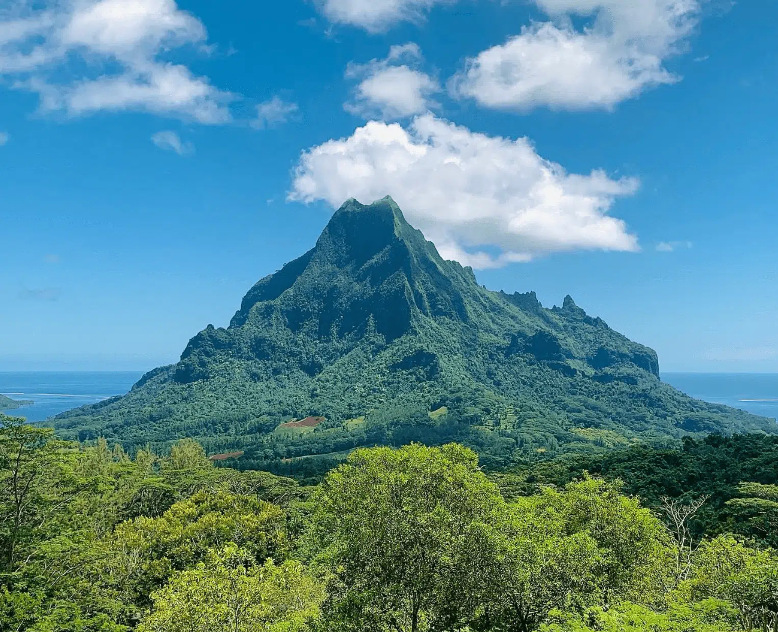
Rotui is a spectacular peak located on the beautiful island of Moorea in French Polynesia.
It is the second-highest peak in Moorea, with 899 meters (2,949 feet), surpassed only by Mount Tohiea, which is 1,207 meters (3,960 feet) high.
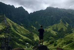
While Moorea, Tahiti, and Bora Bora (with its Mount Otemanu) are popular tourist destinations, the mountains often remain untouched. In fact, there is only one practical route to finish the exciting climb.
On the trail, it’s not uncommon to find yourself completely alone. Most people stay close to the lagoon, beaches, and resorts.
DID YOU KNOW: The island is famous for its more than dozen Moorea hiking trails, which lead to waterfalls, peaks, and viewpoints.
Mount Rotui Hiking Trail Details
Trail overview of Mount Rotui
- Location: Trailhead is near Cook’s Bay, northern Moorea, French Polynesia.
- Trail length: 7 kilometers (4.3 miles) roundtrip.
- Duration: It takes approximately 5 to 6 hours to complete.
- Difficulty: Rated hard due to steep inclines and exposed ridges.
- Elevation gain: 899 meters (2,950 feet).
- Best time to hike: Start between 6:00 a.m. and 7:00 a.m. for cool weather and clear views.
- Permits necessary: None, but notify someone of your plans for safety as people have died on this track.
TRIPADVISOR REVIEW: I hesitate to call this a “hike” but it wouldn’t be technically correct to call it a climb… perhaps some sort of hybrid, as there is plenty of scrambling, relying on ropes (if you dare) and walking overgrown trails across razor-ridge spines with serious exposure below.
Starting point of Mount Rotui
Access: The trail head for Mount Rotui is located near the Hilton Moorea Lagoon Resort and Spa, making it a convenient starting point if you are staying nearby.
You can download the trail for free on AllTrails.
Trail description of Mount Rotui
Initial section:
- Begins with a steep ascent through tropical vegetation.
- Features a variety of native flora and fauna, offering an immersive nature experience.
- The path is easy to follow.
Midway point:
- The trail becomes steeper and narrower, requiring careful navigation for the hot climb.
- Includes sections with loose rocks and exposed ridges that demand attention and balance.
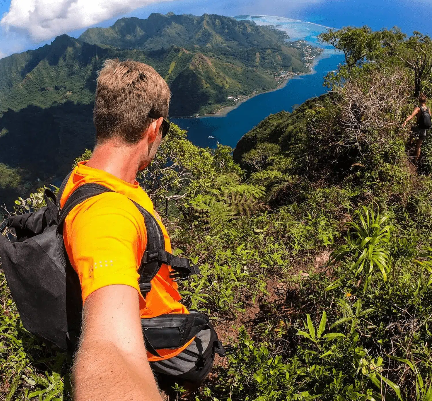
- Offers stunning views of Cook’s Bay and Opunohu Bay, with rest spots to enjoy the scenery.
Final ascent:
- The most challenging section, with a steep and strenuous climb to the summit.
- Requires careful footing and scrambling over rocks.
- The summit provides breathtaking panoramic views of Moorea and the surrounding turquoise lagoon.
Simply fill in the form below to get a FREE QUOTE from trusted local travel specialists who know the islands inside out.
It only takes 60 seconds, and you’ll receive custom itineraries and pricing directly in your inbox or WhatsApp within
48 hours.
Free of charge. No pressure. No obligation.
*Our trusted local partners create every itinerary with care. We kindly ask that you submit a request only if you’re considering traveling.
How to get to the trailhead of Mount Rotui
By Bus:
- Bus schedules on Moorea are aligned with ferry arrivals at Vai’are Ferry Terminal.
- Route to Trailhead: From Vai’are, board a bus heading north towards Faimano Village. Inform the driver that you want to climb Mount Rotui, and he will make a stop along his route for you.
- Locating the Trailhead: In Faimano Village, look for a driveway marked by a sign reading “Art Deko.” Proceed down this driveway until you see another sign labeled “Rotui“ with an arrow pointing to the right. Follow the arrow to reach the trail’s starting point.
- The fare is approximately $3 USD (€2.50) each way.
By Car:
- Car Rentals: Renting a car offers flexibility and convenience. Agencies like Avis have offices at the ferry terminal and airport.
- Driving Directions: From Vai’are Ferry Terminal, take the Ring Road (Route de Ceinture) north towards Faimano Village. Approximately 15 kilometers (9.3 miles) into the drive, look for the “Art Deko” sign on your left. Turn into the driveway and follow the “Rotui” sign directing you to the right.
Alternative Start from Ta’ahiamanu:
- Access Point: Begin at Ta’ahiamanu Beach (a public beach) and walk northeast towards the mountain. Locate the trail head leading to the ridgeline, which connects to the main path up Mount Rotui.
INSIDER TIP: Bus services on Moorea do NOT OPERATE ON SUNDAYS.
Scenic Highlights
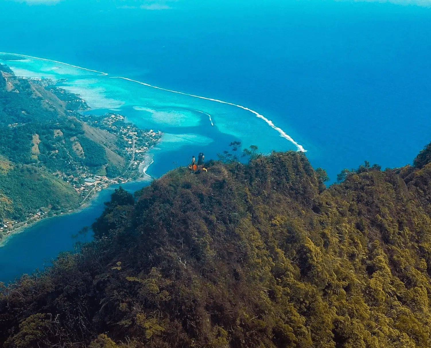
Cook’s bay
As you begin your hike, you’ll quickly be rewarded with spectacular views of Cook’s Bay.
Known for its turquoise waters, this bay is surrounded by green peaks that seem to rise directly from the ocean.
The contrast between the water and the mountains creates a POSTCARD-PERFECT SCENE.
Opunohu Bay
Shortly after enjoying the views of Cook’s Bay, the trail offers scenic views of Opunohu Bay.
From the trail, you can see the curves of the coastline and the way the bay connects to the surrounding greenery.
Together with Cook’s Bay, these two iconic bays make the early sections of this challenging hike unforgettable.
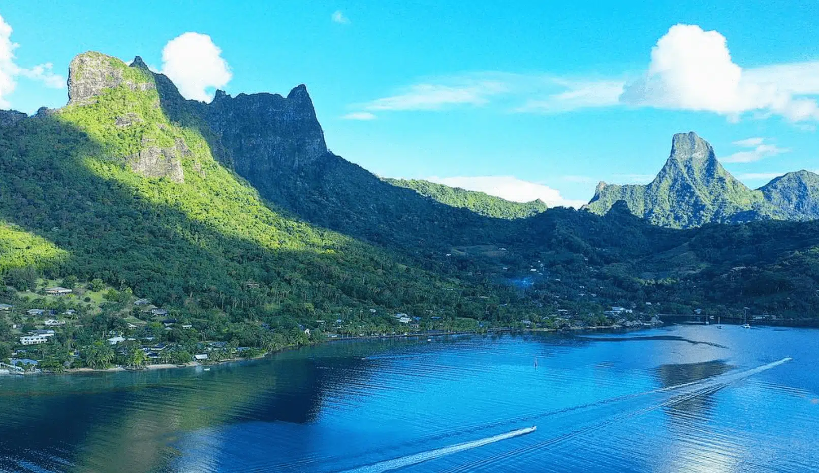
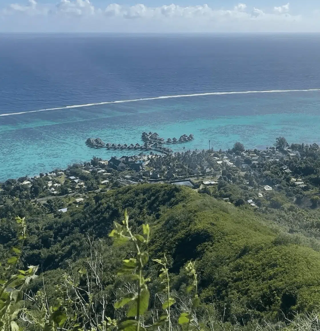
Summit experience
The summit of Mount Rotui offers the ultimate reward: a 360-degree panoramic view of Moorea and its blue waters.
From this vantage point, you can take in the jagged peaks, rolling valleys, and shimmering lagoons that define the island.
When to hike Mount Rotui
The best time to hike Mount Rotui is during the DRY SEASON, running from June through September. These driest months offer the best conditions for climbing, with almost no rain and clear skies.
The shoulder months of May and October are also perfect times to make the strenuous hike on this magical mountain. While some rain showers may be, the trail is generally manageable, and the weather is less humid than in the wetter months.
April can be unpredictable—a transitional month where conditions vary from dry to wet.
If you plan to hike in April, always check local weather forecasts and our complete article on the best time to visit French Polynesia.
We do not recommend train hiking in the wet season!
INSIDER TIP: Start your hike early, around 6:00 a.m. to avoid the midday heat.

Opening
The trail is open seven days a week.
Check the latest opening times on the official Tahiti Tourism page.
Prices
Hiking Mount Rotui is a free activity, as no entrance fees or permits are required to access the trail.
Essential Tips
- Start early: Begin your hike between 6:00 a.m. and 7:00 a.m. to avoid the midday heat and enjoy clearer views.
- Wear long pants: Protect your legs from vegetation, insects, and scrapes along some of the overgrown trails.
- Wear proper footwear: Sturdy hiking boots with good grip are essential for navigating steep and slippery sections.
- Pack plenty of water: Carry at least 2 litres of water (68 oz) per person. The tropical heat and strenuous climb make hydration crucial.
- Dress appropriately: Wear lightweight, breathable clothing and apply sunscreen. A hat and sunglasses will help protect against the intense sun.
- Bring snacks: High-energy snacks like nuts, granola bars, or dried fruit will keep you fueled throughout the hike.
- The hike can be challenging: Prepare for steep sections and scramble in certain areas.
- Respect the natural environment: Leave no trace and pack out all trash.
- Inform someone of your plans: Notify your accommodation about your hiking itinerary, especially if you’re hiking solo.
Pay attention: people have been killed
Mount Rotui only has one feasible route.
A Texan party did try to climb an alternative route, the southwest route, a few years ago, but they were killed when the pitons pulled out.
The most practical path to the summit is the North Ridge Route.
This trail begins near the Faimano Village Hotel, across the road from the trailhead. The route is characterized by a steep ascent, passing through flame tree groves before reaching the north ridge.
Along the way, you will encounter sections requiring vines for support on the steeper parts. In some particularly challenging spots, fixed ropes are available to assist you.
Simply fill in the form below to get a FREE QUOTE from trusted local travel specialists who know the islands inside out.
It only takes 60 seconds, and you’ll receive custom itineraries and pricing directly in your inbox or WhatsApp within
48 hours.
Free of charge. No pressure. No obligation.
*Our trusted local partners create every itinerary with care. We kindly ask that you submit a request only if you’re considering traveling.
Conclusion
Hiking Mount Rotui is a challenging yet enriching adventure that offers some of the most breathtaking views in French Polynesia.
From the turquoise bays to the panoramic vistas and the summit’s 360-degree views, every journey step immerses you in Moorea’s natural beauty.
With proper preparation, respect for the environment, and awareness of your limits, this hike can be a truly unforgettable experience.
Are you ready to conquer Mount Rotui and create lifelong memories?
FAQ
How tall is Moorea Mountain?
Moorea's tallest mountain is Mount Tohiea, which stands at 1,207 meters (3,960 feet) above sea level.
What is the highest point on Moorea?
The highest point on Moorea is the summit of Mount Tohiea, the island's tallest and most prominent peak, which stands at 1,207 meters (3,960 feet) above sea level..
What is the hole in the mountain in Moorea?
The "hole in the mountain" refers to Mount Mouaputa, a striking peak with a natural hole near its summit. According to legend, this hole was created by a spear thrown by the demigod Pai.
What is special about Moorea?
Moorea is renowned for its breathtaking landscapes, including lush green mountains, turquoise lagoons, and white sandy beaches. It offers a unique blend of rugged peaks, such as Mount Rotui and Mount Tohiea, and serene lagoons perfect for relaxation. Its natural beauty, combined with a quieter and more intimate atmosphere compared to Tahiti, makes it a popular destination for couples, adventurers, and nature lovers.
Can you swim in Moorea?
Yes, Moorea is a swimmer’s paradise! The island is surrounded by crystal-clear lagoons, perfect for swimming, snorkeling, and diving. The waters are calm, warm, and teeming with marine life, making them ideal for all skill levels.
How high is Magic Mountain Moorea?
Magic Mountain stands at approximately 207 meters (679 feet) above sea level. Though not as tall as Moorea’s major peaks, it offers incredible panoramic views of the island’s lagoons and lush valleys, making it a must-visit spot.


2 Responses
Did you summit?
Hi Jason, we visited Moorea last year but did not have the chance to climb Rotui ourselves. Our friends from SailingWapiti did and we have based our post on their experiences as well as two local tour operators! Hope you enjoyed the post!